Pictures from Israel
 Click to Enlarge
This is the entrance to the City of David, however this is not King David playing the harp ! ….it is Avir.
He is about to do the walking tour of the City of David, including passing through the underground tunnels through which the city was conquered and residents fled and he is also going to the hidden spring where kings were crowned. Walking in Hezekiah’s Tunnel, is quite exciting. This is an area where water has flowed since the time of the prophets.
The City of David is the birthplace of the city of Jerusalem, the place where King David established his kingdom, and where the history of the People of Israel was written was located on a narrow ridge south of the present-day ‘Old City’. It borders the deep Kidron Valley to the East, where the Gihon Spring, the city’s main water source, is located.
King David finally captured the city at about 1,000 BC. David’s soldiers entered into the city of the Jebusites through the gutter, probably the tunnel of the Gihon spring (2 Samuel 5 6-9). This archaeological park is one of Israel’s most important historical landmarks, a must-see site for all tourists, including Avir.
Pictures from Israel
 Click to Enlarge
In this picture Avir is in the gardens of Safra Square, as part of the City Hall complex in Jerusalem.
Spring time is a wonderful and colourful time to be in Safra Square as the flowers are at their best, and at the right time of day, the shadows are spectacular.
Avir is looking at a model of the whole City Hall complex, which highlights so many old and new buildings in this historic centre of Jerusalem. The city planers were careful to create a modern City Hall complex which blended into the architectural and historical character of the neighbourhood, as well as meeting the physical requirements a functional administration.
The site of the City Hall complex was chosen because it is the centre of Jerusalem between east and west, close to the Old City and Jaffa Road, one of the oldest and longest major streets in the city which leads to the town of Jaffa and the City of Tel Aviv.
Many of the City’s walking tours start from Safra Square which has the very regular and efficient Light Rail near-by.
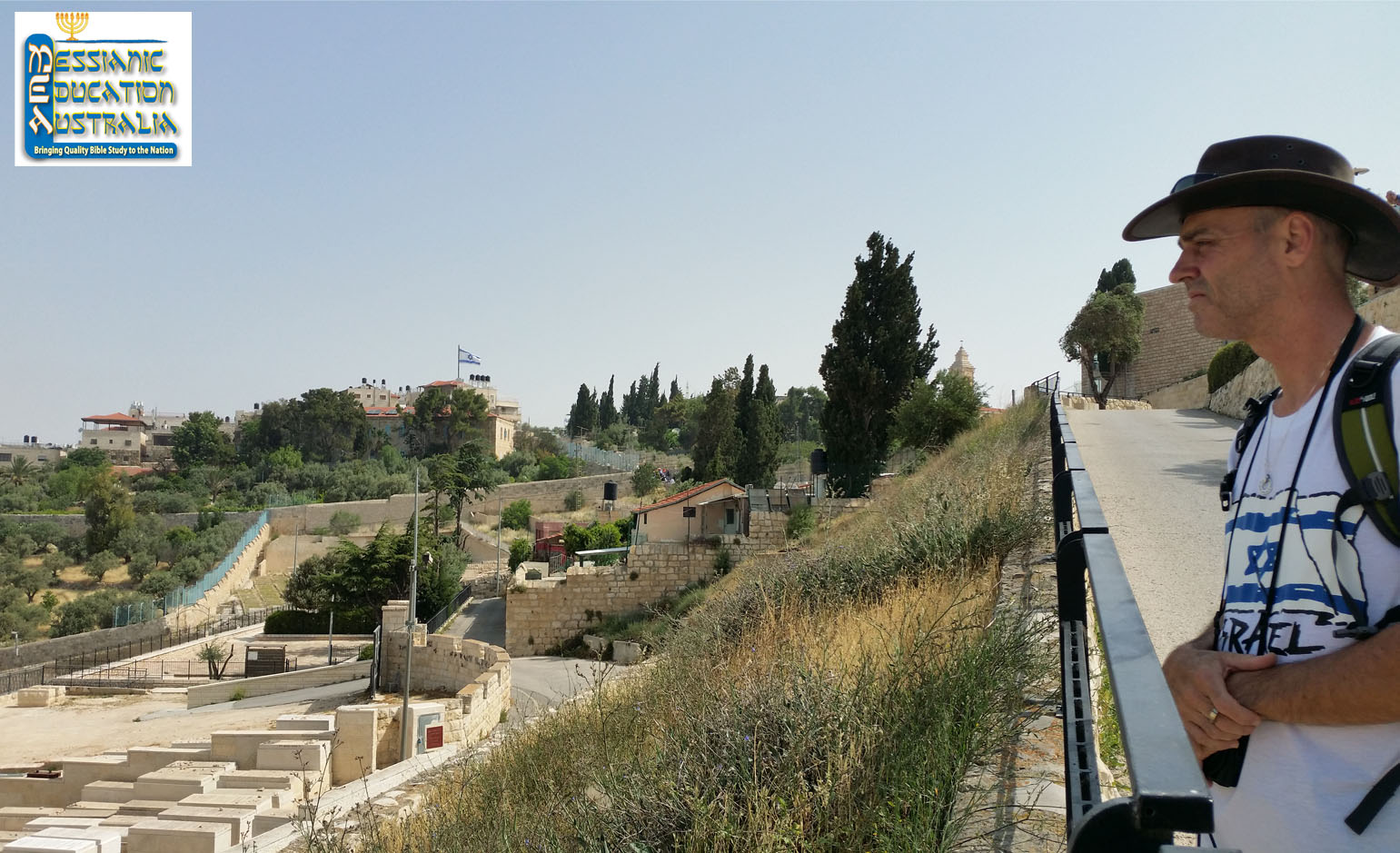
Pictures from Israel
 Click to Enlarge
Australian visitor to Israel, Avir is pictured looking over to Jerusalem. You can see the graves in the foreground. The Mt. of Olives has always been an important feature in Jerusalem’s landscape
Within Judaism and Christianity, the Mt of Olives plays an important role in the return of the Messiah, King of Kings.
From the 3rd millennium B.C. until the present, this 885 metre hill has served as one of the main burial grounds for the city. The 3200 metre long ridge has three summits each of which has a tower built on it. At the bottom of the slope is the Garden of Gethsemane.
Zechariah 14:4
On that day Messiah’s feet will stand
on the Mount of Olives,
which lies to the east of Yerushalayim; (Jerusalem)
Pictures from Israel

Click to enlarge
History of Israel – Gan HaShlosha National Park
Israel is home to many breathtaking natural wonders and a lot of stunning scenery, and the Gan HaShlosha Park, located in the Lower Galilee region is one of them. Gan HaShlosha National Park is full of surprises for any visitors who venture to this part of Israel. Located between kibbutzim Beit Alfa and Nir David, these natural spring waters maintain a constant temperature of 28 degrees Celsius, making it ideal for swimming all year round. The Park’s name in Hebrew literally means ‘Park of the three’, and is also known in Arabic as ‘Sakhne’ meaning ‘The hot’ pool, and is so named in memory of three Jewish pioneers who, in 1938, were killed when their car rode over a land mine while they were surveying the area for the Jewish National Fund.
There are many historical attractions within the Park, including an old water-powered mill operating at the site and a reconstruction of Tel Amal (first built December 10, 1936); one of the first ‘Tower and Stockade’ settlements set up by Jewish pioneers during the 1936-39 Arab Revolt, as a protest against a British ban on the establishment of new Zionist settlements. Tel Amal was one of 52 communities all built on the same night.
The Prophet Ezekiel in the Bible writes this very apt prediction of Israel’s return to its homeland: “The desolate land will be cultivated instead of being a desolation in the sight of everyone who passes by. They will say, “This desolate land has become like the garden of Eden; and the waste, desolate and ruined cities are fortified and inhabited.” (Ezekiel 36:34-35)
The Park is Also home to the Museum of Regional and Mediterranean Archaeology which displays ancient and rare Greek agricultural tools; Egyptian and Persian artefacts excavated from the nearby Beit She’an Valley; an exhibit showing the ancient Italian civilization known as the Etruscans.
Australian visitors will be right at home in the park’s small zoo hosting koalas and kangaroos amongst other Australian wildlife. The park has two other unique events: the Israeli Juggling Convention, the second largest juggling convention in the world, drawing in over 2,000 jugglers each year; and also the location for Israel’s biggest yoga festival.
Copyright exists in all the material on this website and is owned by Messianic Education Australia Ltd. unless otherwise explicitly stated. This copyright extends to the images, logos, layout and presentation styles as well as the text material.
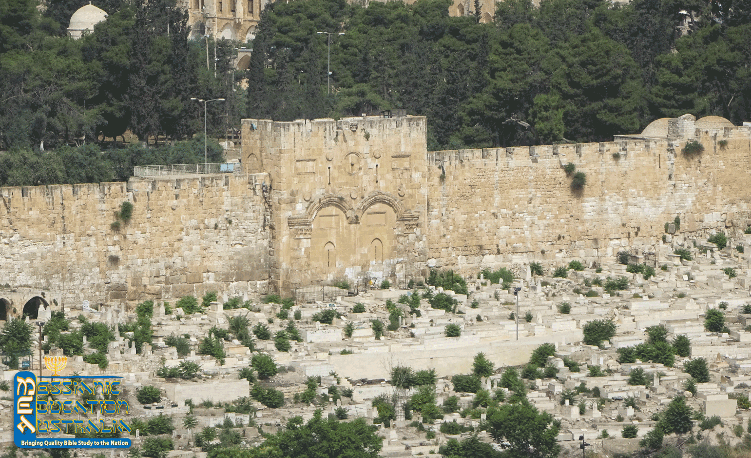
Pictures from Israel

Click to enlarge
History of Israel – Jerusalem’s Golden Gate
The Old City of Jerusalem is surrounded by a wall containing eight major gates. The Eastern Gate, facing the Mount of Olives across the Kidron Valley, is unique in that it was sealed shut by the Ottoman Empire under Suleiman the Magnificent in 1540-41 A.D. who believed that sealing up the Golden Gate would prevent the coming Jewish Messiah from gaining entrance to Jerusalem to rule and reign.
The Eastern Gate of Jerusalem is also called the Golden Gate or the Beautiful Gate (Acts 3:2). In Hebrew, it is Sha’ar Harahamim, the “Gate of Mercy.” It is currently the oldest gate in the Old City, (6th or 7th century A.D.) built on top of the original ancient Golden Gate which may date back to the time of Nehemiah.
Yeshua used this gate when entering Jerusalem from the Mount of Olives. It’s the sealing of Jerusalem’s Eastern Gate that has caused many students of prophecy to sit up and take notice. The book of Ezekiel contains several references to a gate that faces east. In Ezekiel 10:18-19, the prophet sees the glory of the Lord leave the Temple through:
“They paused at the entrance to the east gate of Adonai’s house”; “Next, the glory of Adonai rose from within the city and stood over the mountain which is on the east side of the city” (Ezekiel 11:23). Later, Ezekiel sees the glory of the Lord return to the temple via “the gate facing east” (Ezekiel 43:1-5).
Some interpret these passages in Ezekiel as references to the Messiah. The glory of the Lord coming into the temple is the triumphal entry (Ezekiel 43:2; Matthew 21:1–11).
Copyright exists in all the material on this website and is owned by Messianic Education Australia Ltd. unless otherwise explicitly stated. This copyright extends to the images, logos, layout and presentation styles as well as the text material.
Pictures from Israel

Click to enlarge
History of Israel –Ancient Nabatean city of Mamshit
Mamshit, or its Arab name Mamshit-Kurnub, or even Mampsis to the Greeks, is located on hills above the Mamshit River gorge in the Negev Desert adjacent to the Dead Sea. The setting of Mamshit, against the soft desert hills and azure sky, is spectacular. Some buildings have been reconstructed which show what the city looked like in the first century B.C.E.
Historically, Mamshit was an important trade-centre on the popular incense and spices road, which connected the east (Yemen and Oman) through Arabia via the Nabatean capital city Petra, and on to the port cities on the shore of the Mediterranean Sea, as well as Eilat, Beer-Sheva, Hebron and Jerusalem.
During its history, Mamshit city has been ruled by ancient Nabatean, Roman and Byzantine empires and before this, Nabatean history goes back thousands of years, starting close to the time when the Babylonians under Nebuchadnezzar who, in 586 B.C.E. captured Jerusalem and exiled most of the Jewish people. When the Nabateans (who were originally a nomadic people from the Arabian Peninsula), took over Mamshit, they established stations and fortresses along this trade route. However, they were conquered by the Romans who built a wall around the city, which remained intact until the late fourth century C.E. After them, the Byzantines occupied the city for three centuries and built many structures including two churches which continued to be used until the Arab conquest. From that time, Mamshit fell into disrepair and virtually ceased to exist. In 1936 the British Mandatory government built a police station over the ruins of an ancient Nabataean building on one of the highest parts of Mamshit, as well as establishing the Desert Mounted Police to supervise Beduins and Jews in the northern Negev.
Mamshit is the best restored in the Negev Desert, which is carefully maintained by Israel Nature and Parks Authority. The city area itself is small enough to walk around in about an hour—a tourist’s delight.
Among the ruins were many large wealthy homes. One is a 1,600 square-metre house, with courtyards, stairways and stables, showing the individual wealth of its owner, who for reasons unknown, left behind (for the archaeologists to find), some 10,500 silver coins dated between 222 and 275 C.E.
Israel © MEA-20180523 (J442) History of Israel -Nabatean city of Mamshit
Copyright exists in all the material on this website and is owned by Messianic Education Australia Ltd. unless otherwise explicitly stated. This copyright extends to the images, logos, layout and presentation styles as well as the text material.


